
Wirbelstürme
249 Beiträge ▪ Schlüsselwörter:
Sanba Taifun Wirbelsturm ▪ Abonnieren: Feed E-Mail

Wirbelstürme
29.10.2012 um 15:00Zeitgleich mit Vollmond soll noch eine Sonnenerruption, deren Auswirkung wir am Montag, Dienstag spueren sollten, dazukommen.
Alles etwas viel aufs Mal.
Alles etwas viel aufs Mal.
Wirbelstürme
29.10.2012 um 15:17@habiba
Was soll den die Sonneneruption für einen Einfluss auf Ebbe & Flut haben :D ? Nach Erdbeben nun also auch noch Wirbelstürme als Folge (?), naja. Der noch an der Erde vorbei geht. Scheint mir weit her geholt:
Also mir völlig schleierhaft was davon ne Auswirkung sein soll.
Was soll den die Sonneneruption für einen Einfluss auf Ebbe & Flut haben :D ? Nach Erdbeben nun also auch noch Wirbelstürme als Folge (?), naja. Der noch an der Erde vorbei geht. Scheint mir weit her geholt:
SLOW ERUPTION: The magnetic canopy of a sunspot group just over the sun's southwestern limb slowly erupted on Oct. 28th. When the hours-long eruption was over, this bright arcade formed over the blast site, marking the location where the explosion occured:http://spaceweather.com/
Arcade loops appear after many solar flares. It is how the magnetic fields of sunspots settle down after a significant eruption. This particular eruption hurled a massive CME into space, but Earth was not in the line of fire. As the movie shows, the explosion was photogenic, but not geoeffective.
Also mir völlig schleierhaft was davon ne Auswirkung sein soll.
Wirbelstürme
29.10.2012 um 15:21@jojo72
Also es gibt gewisse Paralellen zwischen Unwettern und Sonneneruptionen. Ich moechte mich da aber keinesfalls irgendwie festlegen und kann auch nicht sagen, dass ich daran glaube. Man muesste das ganze noch mehr unter die Lupe nehmen.
Anyway, es ist bestimmt nicht hilfreich, wenn man im Moment eines solchen Sturmes noch mit anderen Unannehmlichkeiten konfrontiert werden koennte, wie zbsp. Stromausfall oder Instrumente, Navigationen, Satelliten etc. die spinnen oder ausfallen.
Wirbelstürme
29.10.2012 um 15:23@jojo72
zu deinem Link: Hatte gestern wo anders gelesen, dass die Erde im Bereich liegt, aber dass die Eruption eher schwach sei und es womoeglich auf der noerdlichen Halbkugel zu Stoerungen von Telefonen und Radios kommen koennte.
zu deinem Link: Hatte gestern wo anders gelesen, dass die Erde im Bereich liegt, aber dass die Eruption eher schwach sei und es womoeglich auf der noerdlichen Halbkugel zu Stoerungen von Telefonen und Radios kommen koennte.
Wirbelstürme
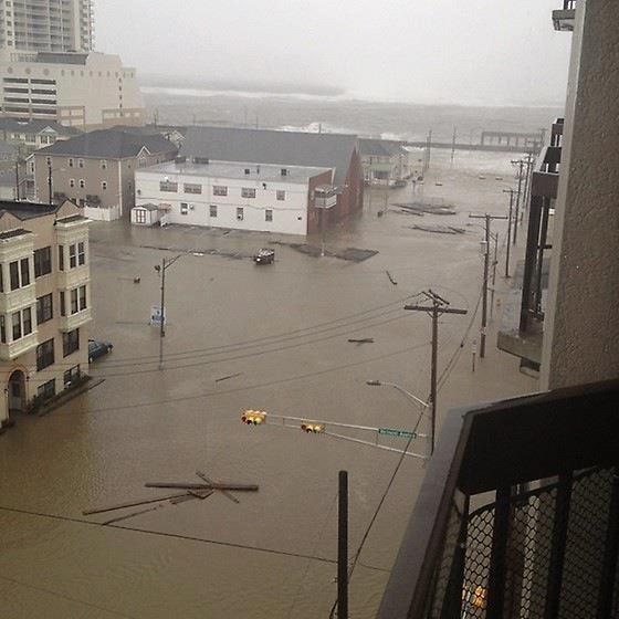
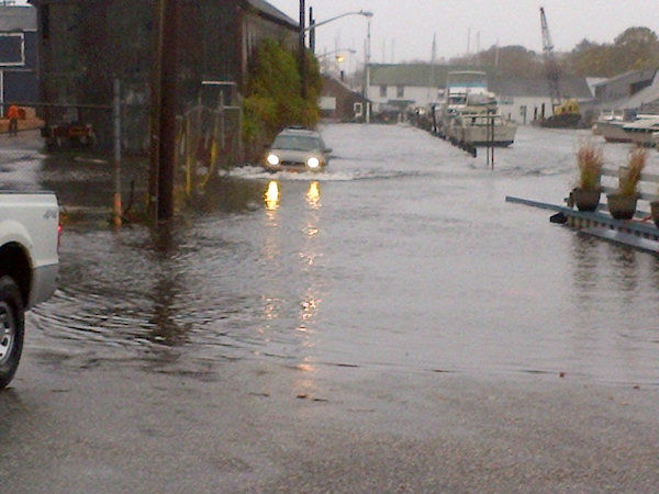
29.10.2012 um 15:24Also aktuell benötigt das nicht einmal die Flut, Atlantic City, NC:

Und Sandy ist noch mehr als 200km von der Küste entfernt, läuft noch immer NNW.
Und Sandy ist noch mehr als 200km von der Küste entfernt, läuft noch immer NNW.

Wirbelstürme
29.10.2012 um 15:46Livecams vom New Yorker Hafen gehen nicht mehr.
Wirbelstürme
29.10.2012 um 15:53Druck fällt und fällt, Sandy wird deutlich stärker aktuell.... 943mb, 90mph...
Long Island:
Atlantic City:
Long Island:
Atlantic City:

Wirbelstürme
29.10.2012 um 16:08@DeepThought
die hier geht noch:http://www.ellisisland.org/TorchCam/Streaming.asp#
hier ein aktuelles bild:
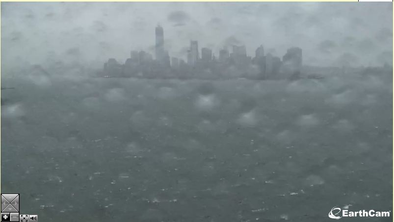
die hier geht noch:
hier ein aktuelles bild:
Wirbelstürme
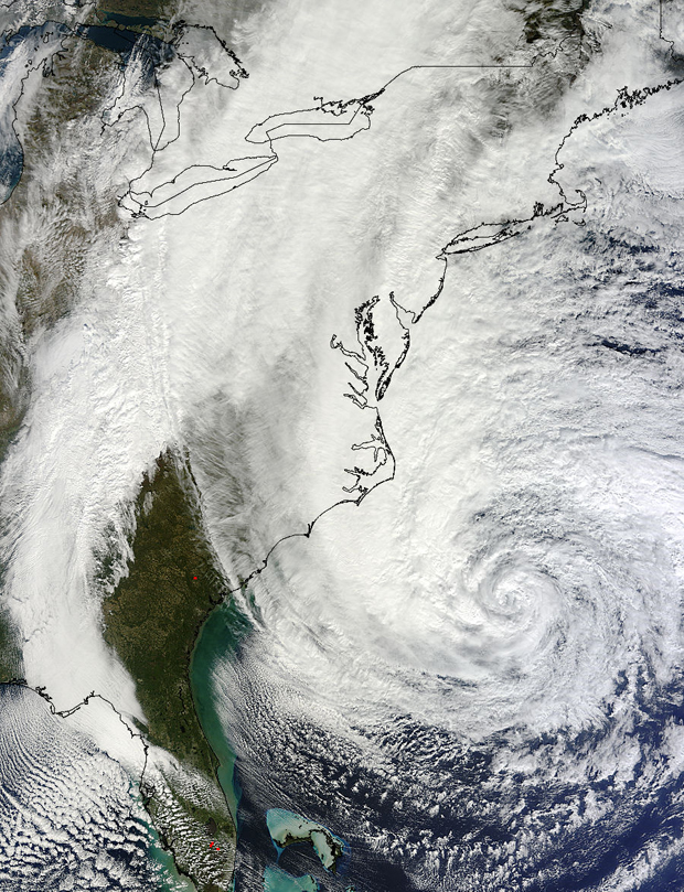
29.10.2012 um 17:25"Superstorm", "Perfect Storm", alles was man so liest in amerikanischer Presse. Und für einmal wohl nicht übertrieben, Sandy ist nahe an einem Jahrhundertsturm. Nimmt selber nochmals an Fahrt auf und vereinigt sich mit einem sonst schon grossen Wettersystem über dem Nordosten der USA. Nun rechnen sie schon mit Schnee bin runter nach Florida. Alles passt.
Tschuldigung das ich das nicht übersetze, das übernimmt sonst google.com/translate. Aber das sollte dokumentiert werden fürs Archiv mal in Zukunft:
Aktuell Grenzfall zur Kategorie 2. Und die Hürde nimmt er wohl noch.
Tschuldigung das ich das nicht übersetze, das übernimmt sonst google.com/translate. Aber das sollte dokumentiert werden fürs Archiv mal in Zukunft:
Superstorm Sandy intensifying, bringing record storm surgeshttp://www.wunderground.com/blog/JeffMasters/comment.html?entrynum=2280
Posted by: Dr. Jeff Masters, 02:54 PM GMT am 29. Oktober 2012 +35
The final countdown to Hurricane Sandy's arrival has begun, and this extraordinary and historic storm is already causing havoc all along the U.S. coast from North Carolina to Massachusetts. The scale of this massive storm truly earns Sandy the title of "superstorm". Sandy's tropical storm-force winds span an area of ocean 940 miles in diameter, and both North Carolina and the island of Bermuda, 700 miles to the east, are under tropical storm warnings. The region of ocean covered by 12-foot high seas spans an area of ocean an incredible 1560 miles in diameter. Winds near hurricane force are expected to affect waters from Virginia to Massachusetts today. Record storm surge flooding has already occurred in regions along the New Jersey coast this morning, and the highest water levels recorded in over a century of record keeping are expected over much of the New Jersey and New York coasts this evening during the 8 - 9 pm EDT high tide cycle. Sandy brought sustained winds of 60 mph and waves 30 feet high early this morning to the buoy east of Cape Hatteras, NC. A wind gust of 58 mph occurred at New York City's La Guardia Airport at 9:51 am EDT, and a buoy at Robins Reef, NJ recorded sustained winds of 42 mph, gusting to 55 mph. As of 8 am EDT, Sandy has dumped heavy rains of 7.87" at Cape Hatteras, NC; 4.01" at Ocean City, MD; 3.12" at Dover, DE; and 3.22" at Virginia Beach, VA. As of 9 am EDT, peak storm surge values of 5" were observed at Lewes, Delaware, 4.2' at Cape May, NJ, 4' at Atlantic City, NJ, 2.9' at Philadelphia, and 3.9' at New York City.
Latest data from the Hurricane Hunters shows that Sandy is intensifying as its core traverses the warm waters of the Gulf Stream. At 8 am EDT, an Air Force hurricane hunter aircraft found top winds of 98 mph in the heavy thunderstorms to the southwest of Sandy's center, at a point about 150 miles east-northeast of Cape Hatteras, NC. A dropsonde released in the eye measured a central pressure of 945 mb, but observed winds of 19 knots at the surface, so Sandy is probably a 943 mb hurricane that is very close to Category 2 strength. The Hurricane Hunters did not observe an eyewall, and saw very little temperature difference from inside to outside the eye, so Sandy is not going to be able to undergo rapid intensification. The storm could still see an increase of 5 mph in its winds before landfall tonight between 6 pm - 10 pm EDT, due, in part, to interaction with the low pressure system to its west that is pulling the hurricane towards the coast. The new, higher winds of Sandy don't have a lot of time to pile up additional storm surge water, so the NHC storm surge forecasts will probably not change today. But it is clear that Sandy is not going to pull its punch, and this superstorm is going to deliver a punishing multi-billion dollar blow to a huge area of the Eastern U.S.
Aktuell Grenzfall zur Kategorie 2. Und die Hürde nimmt er wohl noch.

Wirbelstürme
29.10.2012 um 17:44Hier wird ein Reporter weg gespült :)
http://abcnews.go.com/GMA/video/hurricane-sandy-reporter-producer-hit-storm-wave-17589749 (Archiv-Version vom 29.10.2012)
http://abcnews.go.com/GMA/video/hurricane-sandy-reporter-producer-hit-storm-wave-17589749 (Archiv-Version vom 29.10.2012)
Wirbelstürme
29.10.2012 um 17:49@Jantoschzacke
Nich so witzig, die Bounty ist abgesoffen vor New Jersey. Küstenwache konnt fast nix schicken. 19 Personen waren an Bord, einige sind verschollen.
Nich so witzig, die Bounty ist abgesoffen vor New Jersey. Küstenwache konnt fast nix schicken. 19 Personen waren an Bord, einige sind verschollen.
Wirbelstürme
29.10.2012 um 17:51http://www.qicknews.de/Monitore/sandy.php/ (Archiv-Version vom 29.10.2012)
mehr Info geht wohl nicht!
mehr Info geht wohl nicht!
schwarzbock

Profil anzeigen
Private Nachricht
Link kopieren
Lesezeichen setzen
dabei seit 2010Unterstützer
Profil anzeigen
Private Nachricht
Link kopieren
Lesezeichen setzen
Wirbelstürme
29.10.2012 um 19:31http://www.n-tv.de/mediathek/spezialstream/
Livestream auf NTV. Der Sturm ist noch gar nicht da und das sieht jetzt schon verdammt ungemütlich aus.
Livestream auf NTV. Der Sturm ist noch gar nicht da und das sieht jetzt schon verdammt ungemütlich aus.
Kyu
Diskussionsleiter

Profil anzeigen
Private Nachricht
Link kopieren
Lesezeichen setzen
dabei seit 2005
Profil anzeigen
Private Nachricht
Link kopieren
Lesezeichen setzen
Wirbelstürme
29.10.2012 um 19:42+++ Schon Zehntausende ohne Strom +++
Die Meteorologen korrigieren ihre Angaben erneut nach oben: "Sandy" wird beständig stärker, der Landfall wird gegen 01.00 Uhr MEZ südlich von New York erwartet. Dort soll es bis zu sechs Meter hohe Flutwellen geben. Einzelne New Yorker Stadtteile könnten dann drei Meter unter Wasser stehen. Schon jetzt sind 61.000 Menschen an der Ostküste ohne Strom.
Quelle: http://www.n-tv.de/panorama/Schon-Zehntausende-ohne-Strom-article6005131.html
LIVE-Streams http://www.qicknews.de/Monitore/sandy.php/ (Archiv-Version vom 29.10.2012)

Wirbelstürme
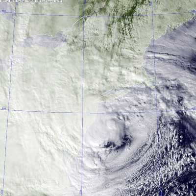
29.10.2012 um 19:43am gigantischsten sind die bilder vom nasa GOES Sataltite
http://goes.gsfc.nasa.gov/ (Archiv-Version vom 29.10.2012)
http://goes.gsfc.nasa.gov/ (Archiv-Version vom 29.10.2012)
Wirbelstürme
29.10.2012 um 20:08Ist nicht mehr so weit:

Wirbelstürme
29.10.2012 um 20:09Sandy occupys Wall Street. :D
Wirbelstürme
29.10.2012 um 20:11seit mal ehrlich
könnte es nicht einen perfekteren zeitpunkt geben für einen tornado inmitten amerikas. inmitten der wahlen und börsenkrise ? zudem hab ich sogar hier in deutschland in den letzten Tagen krasse Wetterentwicklungen beobachten können. klingt zwar wieder verschwörungstheoretisch aber das "horror-szenario" 2012 zeigt immer mehr fakten bzw die medien und zuständige leiten einige schritte ein wozu auch immer
aufjedenfall ein beachtlicher Sturm der sich da entwickeln wird, warten wir ab :D

Wirbelstürme
29.10.2012 um 20:12Naja, wird ja überwiegend an NYC vorbei ziehen. Aber spüren tun sie es ja jetzt schon. :D