Natur
Menschen Wissenschaft Politik Mystery Kriminalfälle Spiritualität Verschwörungen Technologie Ufologie Natur Umfragen Unterhaltung
weitere Rubriken
PhilosophieTräumeOrteEsoterikLiteraturAstronomieHelpdeskGruppenGamingFilmeMusikClashVerbesserungenAllmysteryEnglish
Diskussions-Übersichten
BesuchtTeilgenommenAlleNeueGeschlossenLesenswertSchlüsselwörter
Schiebe oft benutzte Tabs in die Navigationsleiste (zurücksetzen).

Quake Watch 2011

3.804 Beiträge ▪ Schlüsselwörter: Weltuntergang, Japan, Ende ▪ Abonnieren: Feed E-Mail

Quake Watch 2011

29.04.2011 um 16:04
http://hisz.rsoe.hu/alertmap/index2.php?lang=

Magnitude: 5.1
Mercalli scale: 5
Date-Time [UTC]: 29 April, 2011 at 09:38:34 UTC
Local Date/Time: Friday, April 29, 2011 at 09:38 in the moorning at epicenter
Location: 19° 18.600, 167° 53.400
Depth: 60 km (37.28 miles)
Region: Pacific Ocean - West
Country: Vanuatu
Distances: 127.5 km (79.22 miles) S of Bouniakoup,

EDIS Number: EQ-20110429-196576-VU Common Alerting Protocol
Magnitude: 5.1
Mercalli scale: 5
Date-Time [UTC]: 29 April, 2011 at 07:21:12 UTC
Local Date/Time: Friday, April 29, 2011 at 07:21 in the moorning at epicenter
Location: 19° 9.000, 167° 54.600
Depth: 29 km (18.02 miles)
Region: Pacific Ocean - West
Country: Vanuatu
Distances: 120.0 km (74.56 miles) S of Bouniakoup,

Magnitude: 5.0
Mercalli scale: 5
Date-Time [UTC]: 29 April, 2011 at 07:36:27 UTC
Local Date/Time: Friday, April 29, 2011 at 07:36 in the moorning at epicenter
Location: 19° 10.800, 167° 55.800
Depth: 80 km (49.71 miles)
Region: Pacific Ocean - West
Country: Vanuatu
Distances: 118.9 km (73.88 miles) S of Bouniakoup,
Source: EMSC

EDIS Number: EQ-20110429-196589-VU Common Alerting Protocol
Magnitude: 4.8
Mercalli scale: 5
Date-Time [UTC]: 29 April, 2011 at 09:47:23 UTC
Local Date/Time: Friday, April 29, 2011 at 09:47 in the moorning at epicenter
Location: 19° 27.600, 167° 48.600
Depth: 121 km (75.19 miles)
Region: Pacific Ocean - West
Country: Vanuatu
Distances: 142.0 km (88.23 miles) S of Bouniakoup,
Source: EMSC

Anzeige
melden

Quake Watch 2011

29.04.2011 um 16:04
http://hisz.rsoe.hu/alertmap/index2.php?lang= (Archiv-Version vom 29.04.2011)

EDIS Number: EQ-20110429-196584-ID Common Alerting Protocol
Magnitude: 5.5
Mercalli scale: 6
Date-Time [UTC]: 29 April, 2011 at 08:56:49 UTC
Local Date/Time: Friday, April 29, 2011 at 08:56 in the moorning at epicenter
Location: 3° 57.000, 95° 47.400
Depth: 60 km (37.28 miles)
Region: Indonesian Archipelago
Country: Indonesia
Distances: 38.76 km (24.08 miles) SW of Lhokbubon,
Source: EMSC


melden

Quake Watch 2011

29.04.2011 um 16:11
http://hisz.rsoe.hu/alertmap/index2.php?lang= (Archiv-Version vom 29.04.2011)

EDIS Number: EQ-20110429-196599-PH Common Alerting Protocol
Magnitude: 5.4
Mercalli scale: 6
Date-Time [UTC]: 29 April, 2011 at 13:12:47 UTC
Local Date/Time: Friday, April 29, 2011 at 13:12 in the afternoon at epicenter
Location: 21° 13.200, 122° 11.400
Depth: 191 km (118.68 miles)
Region: Pacific Ocean - West
Country: Philippines
Distances: 56.88 km (35.34 miles) of Santa Rosa,
Source: EMSC


melden

Quake Watch 2011

30.04.2011 um 11:11
http://earthquake.usgs.gov/earthquakes/recenteqsww/Quakes/usc00032mv.php (Archiv-Version vom 02.05.2011)

Magnitude 6.1
Date-Time

Saturday, April 30, 2011 at 08:19:16 UTC
Saturday, April 30, 2011 at 03:19:16 AM at epicenter
Time of Earthquake in other Time Zones

Location 6.828°N, 82.281°W
Depth 10 km (6.2 miles)
Region SOUTH OF PANAMA
Distances 178 km (110 miles) S of David, Panama
200 km (124 miles) SW of Santiago, Panama
222 km (137 miles) SSE of Golfito, Costa Rica
384 km (238 miles) SW of PANAMA CITY, Panama
Location Uncertainty horizontal +/- 14.8 km (9.2 miles); depth +/- 2.8 km (1.7 miles)
Parameters NST=348, Nph=353, Dmin=374 km, Rmss=1.37 sec, Gp= 79°,
M-type=regional moment magnitude (Mw), Version=9
Source

USGS NEIC (WDCS-D)

Event ID usc00032mv


melden

Quake Watch 2011

30.04.2011 um 11:13
http://hisz.rsoe.hu/alertmap/index2.php?lang= (Archiv-Version vom 29.04.2011)

EDIS Number: EQ-20110430-196663-PG Common Alerting Protocol
Magnitude: 5.3
Mercalli scale: 5
Date-Time [UTC]: 30 April, 2011 at 05:45:41 UTC
Local Date/Time: Saturday, April 30, 2011 at 05:45 at night at epicenter
Location: 3° 23.400, 148° 35.400
Depth: 60 km (37.28 miles)
Region: Indonesian Archipelago
Country: Papua New Guinea
Distances: 137.5 km (85.44 miles) of Chakol,
Source: EMSC


melden

Quake Watch 2011

30.04.2011 um 11:15
http://hisz.rsoe.hu/alertmap/index2.php?lang= (Archiv-Version vom 29.04.2011)

EQ-20110430-196653-JP Common Alerting Protocol
Magnitude: 5.2
Mercalli scale: 5
Date-Time [UTC]: 30 April, 2011 at 05:06:32 UTC
Local Date/Time: Saturday, April 30, 2011 at 05:06 at night at epicenter
Location: 36° 50.400, 141° 12.600
Depth: 12 km (7.46 miles)
Region: Asia
Country: Japan
Distances: 25.82 km (16.04 miles) of Ena,
Source: EMSC
Generated Tsunami: Not or no data!
Damage: Not or not data!
Additional information (Radius of 100 km)
Nuclear facilities:
Location NPP Distance
Japan Tokai Mura Npp 44.35 km
Japan Fukushima Daiichi Npp 41.72 km
Japan Fukushima Daini Npp 34.41 km
Airport(s):
Location Airport ICAO Type Distance
Japan Fukushima Airport RJSF 50.60 km
Volcanoes: None volcano in the 100-kilometer radius.


3x zitiertmelden

Quake Watch 2011

30.04.2011 um 11:16
http://hisz.rsoe.hu/alertmap/index2.php?lang= (Archiv-Version vom 29.04.2011)

EDIS Number: EQ-20110429-196636-MX Common Alerting Protocol
Magnitude: 5.1
Mercalli scale: 5
Date-Time [UTC]: 29 April, 2011 at 22:31:58 UTC
Local Date/Time: Friday, April 29, 2011 at 22:31 in the evening at epicenter
Location: 28° 49.800, 113° 8.400
Depth: 10 km (6.21 miles)
Region: Middle-America
Country: Mexico
Distances: 27.56 km (17.12 miles) E of San Rafael,
Source: EMSC
Generated Tsunami: Not or no data!
Damage: Not or not data!
Additional information (Radius of 100 km)
Nuclear facilities: There are no nuclear facilities nearby the epicenter.
Airport(s): There are no airport(s) nearby the epicenter.
Volcanoes:
Location Volcano Type Last eruption Distance
MĂŠxico San Borja Volc Field Cinder cones 43.41 km
MĂŠxico Coronado Stratovolcano 28.39 km
The potential impact of the earthquake


melden

Quake Watch 2011

30.04.2011 um 11:17
http://hisz.rsoe.hu/alertmap/index2.php?lang= (Archiv-Version vom 29.04.2011)

EDIS Number: EQ-20110429-196637-JP Common Alerting Protocol
Magnitude: 5.3
Mercalli scale: 5
Date-Time [UTC]: 29 April, 2011 at 22:19:33 UTC
Local Date/Time: Friday, April 29, 2011 at 22:19 in the evening at epicenter
Location: 38° 58.200, 141° 53.400
Depth: 60 km (37.28 miles)
Region: Asia
Country: Japan
Distances: 11.00 km (6.84 miles) of Shirahama,
Source: EMSC
Generated Tsunami: Not or no data!
Damage: Not or not data!
Additional information (Radius of 100 km)
Nuclear facilities:
Location NPP Distance
Japan Onagawa Npp 44.61 km
Airport(s):
Location Airport ICAO Type Distance
Japan Hanamaki Airport RJSI 51.32 km
Volcanoes:
Location Volcano Type Last eruption Distance
Honshu-Japan Kurikoma Stratovolcano 58.95 km


melden

Quake Watch 2011

30.04.2011 um 19:20
Normal oder unnormal für menschen die sich damit relativ wenig befassen ich versteh atm nur bahnhof nur das es einige gegeben hat^^


melden

Quake Watch 2011

30.04.2011 um 20:11
MAP 6.0 2011/04/30 08:19:17 6.878 -82.287 9.9 SOUTH OF PANAMA


melden

Quake Watch 2011

01.05.2011 um 15:11
am 4 - 5-te May befindet sich Mond wieder irgendwo da, wo Sternbild Zwilling ist, absteigender Mond wird also auf dem Wege zum Durchqueren der Ekliptik sein.

Es solle aber auf keinem Fall zu solchem Ergebnis kommen, wie im März 2011 war, weil sich die Erde im May gegen die Richtung der Fortbewegung des Sonnensystem um das Zentrum der Galaxie bewegt, dadurch kommt es zur kleinen Abbremsung der Erdgeschwindigkeit und deswegen ist es auf der Erde relativ ruhig.


melden

Quake Watch 2011

02.05.2011 um 22:26
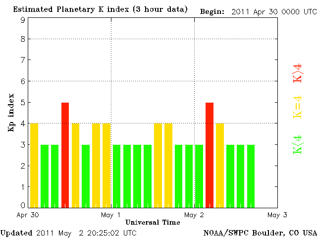
und da kommen noch geomagnetische Stürme dazu, ausgerechnet jetzt
Kp


melden

Quake Watch 2011

04.05.2011 um 15:54
hi,

Interview mit Sergej Pulinez - Multiple Parameter zur Erdbebenvorhersage, bei der Jahrestagung der Europäischen Geowissenschaftlichen Vereinigung sprach Daniel Grasenack-Tente mit Prof. Sergej Pulinez über elektromagnetische und andere Vorboten von Erdbeben und deren Erforschung.

Video deaktiviert


ist zwar mit untertiten aber recht interessant!

mfg matula


melden

Quake Watch 2011

04.05.2011 um 16:01
@matula

BüSO TV....! Danke, keine Fragen mehr...!


melden

Quake Watch 2011

04.05.2011 um 16:16
hach ja...

...bei der Jahrestagung der Europäischen Geowissenschaftlichen Vereinigung...!

die hat sich büso tv einfallen lassen...!?


hast du das video binnen 7 min. angeschaut?!nicht schlecht....!

....................................................................................................

mfg matula


melden

Quake Watch 2011

04.05.2011 um 16:51
@matula

Nee, habe es nicht geschaut, ich habe nur BüSo gelesen, dann hatte ich schon keine Lust mehr...


melden

Quake Watch 2011

05.05.2011 um 19:04
n abend,

2011-05-05 14:58:17.02hr 02min ago 38.30 N 144.04 E 2 mb 6.3 OFF EAST COAST OF HONSHU, JAPAN 2011-05-05 15:33

2011-05-05 14:13:01.02hr 48min ago 55.17 N 160.62 W 40 mb 6.0 ALASKA PENINSULA

http://www.emsc-csem.org/Earthquake/index.php (Archiv-Version vom 05.05.2011)

mfg matula


melden

Quake Watch 2011

05.05.2011 um 19:15
Magnitude mb 5.9
Region ALASKA PENINSULA
Date time 2011-05-05 16:57:39.2 UTC
Location 55.21 N ; 160.55 W
Depth 60 km
Distances 938 km SW Anchorage (pop 276,263 ; local time 08:57:39.2 2011-05-05)
1281 km SW College (pop 11,413 ; local time 08:57:39.2 2011-05-05)
414 km NE Unalaska (pop 3,571 ; local time 08:57:39.2 2011-05-05)

http://www.emsc-csem.org/Earthquake/earthquake.php?id=220417


melden

Quake Watch 2011

08.05.2011 um 09:39
Griechenland: 5.2 http://hisz.rsoe.hu/alertmap/index2.php?lang= (Archiv-Version vom 07.05.2011)

EDIS Number: EQ-20110508-197408-GR Common Alerting Protocol
Magnitude: 5.2
Mercalli scale: 5
Date-Time [UTC]: 08 May, 2011 at 06:50:23 UTC
Local Date/Time: Sunday, May 08, 2011 at 06:50 at night at epicenter
Location: 36° 40.200, 27° 15.600
Depth: 2 km (1.24 miles)
Region: Europe
Country: Greece
Distances: 9.85 km (6.12 miles) of Paloi,
Source: EMSC
Generated Tsunami: Not or no data!
Damage: Not or not data!
Additional information (Radius of 100 km)
Nuclear facilities: There are no nuclear facilities nearby the epicenter.
Airport(s):
Location Airport ICAO Type Distance
Greece Maritsa Airport LGRD 51.10 km
Greece Diagoras Airport LGRP 49.34 km
Greece Leros Airport LGLE 43.69 km
Greece Kos Airport LGKO 12.59 km
Volcanoes:
Location Volcano Type Last eruption Distance
Greece Kos Fumarole fields 10.98 km
Greece Yali Lava domes 9.28 km
Greece Nisyros Stratovolcano 7.63 km
The potential impact of the earthquake


melden
A380 ehemaliges Mitglied

Link kopieren
Lesezeichen setzen

Quake Watch 2011

08.05.2011 um 11:45
@spiky
Zitat von spikyspiky schrieb am 30.04.2011:Magnitude: 5.2
Zufälle gibt es …

2007 waren wir dort und wollten zum Vulkan. Genau in der Nacht davor hatten wir ein 5er Beben. Seitdem gab es dort keine nennenswerten Beben mehr.

Jetzt ist - auf unsere Empfehlung hin - eine Freundin auf Kos und die wollte heute zum Vulkan. Und genau da bebt es wieder. ;)


Anzeige

melden