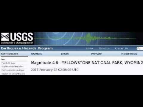
Ein Beben mit 4,6 und niemand merkt was ? hmmmmm
Warum heult ihr so ? bringt doch mal die gelöschten Fakten.
Ein Beben mit 4,6 merkt man nur ganz doof es gab keines !
da manche nicht im Stande sind auf ein Link zu klicken
hier :
Yellowstone Recent Status Report, Updates, and Information Releases
YELLOWSTONE VOLCANO OBSERVATORY MONTHLY UPDATE
Tuesday, February 1, 2011 10:07 AM MST (Tuesday, February 1, 2011 17:07 UTC)
YELLOWSTONE VOLCANO (CAVW #1205-01-)
44°25'48" N 110°40'12" W, Summit Elevation 9203 ft (2805 m)
Current Volcano Alert Level: NORMAL
Current Aviation Color Code: GREEN
During the month of January 2011, 57 earthquakes were located in the Yellowstone National Park region. The largest was a magnitude 2.4 event on January 25 at 9:51 PM MST, located about 6 miles north northwest of West Yellowstone, MT. No earthquake swarms were noted in January 2011.
Earthquake activity during the report period occurred at relatively low background rates.
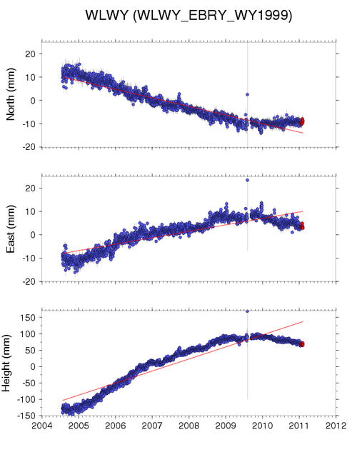
Ground Deformation Summary: Careful analysis of the Yellowstone GPS data shows that the period of accelerated Yellowstone caldera uplift, beginning in 2004, has stopped. Some GPS stations exhibit little change and others reflect slight subsidence. A record of recent ground displacement can be found at:
http://pboweb.unavco.org/shared/scripts/stations/?checkkey=WLWY&sec=timeseries_plots×eries=raw---
The Yellowstone Volcano Observatory (YVO) is a partnership of the U.S. Geological Survey (USGS), Yellowstone National Park, and University of Utah to strengthen the long-term monitoring of volcanic and earthquake unrest in the Yellowstone National Park region. Yellowstone is the site of the largest and most diverse collection of natural thermal features in the world and the first National Park. YVO is one of the five USGS Volcano Observatories that monitor volcanoes within the United States for science and public safety.
CONTACT INFORMATION:
Jacob Lowenstern, USGS
Scientist-in-Charge, Yellowstone Volcano Observatory
jlwnstrn@usgs.gov
Robert Smith, University of Utah
Coordinating Scientist, YVO
Henry Heasler, Yellowstone National Park
Coordinating Scientist, YVO
--------------------------------------------------------------------------------
YELLOWSTONE VOLCANO OBSERVATORY MONTHLY UPDATE
Saturday, January 1, 2011 8:32 AM MST (Saturday, January 1, 2011 15:32 UTC)
YELLOWSTONE VOLCANO (CAVW #1205-01-)
44°25'48" N 110°40'12" W, Summit Elevation 9203 ft (2805 m)
Current Volcano Alert Level: NORMAL
Current Aviation Color Code: GREEN
During the month of December 2010, 80 earthquakes were located in the Yellowstone National Park region. The largest was a magnitude 2.3 event on December 27 at 11:36 PM MST, located about 22 miles east southeast of West Thumb, YNP. This earthquake was part of a small earthquake swarm that occurred December 27 - 28. The swarm consisted of 12 events with magnitudes 2.3 to 0.4.
Earthquake activity continues at background levels.
Ground Deformation Summary: Careful analysis of the Yellowstone GPS data shows that the period of accelerated Yellowstone caldera uplift, beginning in 2004, has decreased. Some GPS stations exhibit little change and others appear to reflect slight subsidence. A record of recent ground displacement can be found at:
http://pboweb.unavco.org/shared/scripts/stations/?checkkey=WLWY&sec=timeseries_plots×eries=raw---
The Yellowstone Volcano Observatory (YVO) is a partnership of the U.S. Geological Survey (USGS), Yellowstone National Park, and University of Utah to strengthen the long-term monitoring of volcanic and earthquake unrest in the Yellowstone National Park region. Yellowstone is the site of the largest and most diverse collection of natural thermal features in the world and the first National Park. YVO is one of the five USGS Volcano Observatories that monitor volcanoes within the United States for science and public safety.
CONTACT INFORMATION:
Jacob Lowenstern, USGS
Scientist-in-Charge, Yellowstone Volcano Observatory
jlwnstrn@usgs.gov
Robert Smith, University of Utah
Coordinating Scientist, YVO
Henry Heasler, Yellowstone National Park
Coordinating Scientist, YVO
--------------------------------------------------------------------------------
YELLOWSTONE VOLCANO OBSERVATORY MONTHLY UPDATE
Thursday, December 2, 2010 12:46 PM MST (Thursday, December 2, 2010 19:46 UTC)
YELLOWSTONE VOLCANO (CAVW #1205-01-)
44°25'48" N 110°40'12" W, Summit Elevation 9203 ft (2805 m)
Current Volcano Alert Level: NORMAL
Current Aviation Color Code: GREEN
During the month of November 2010, 96 earthquakes were located in the Yellowstone National Park region. The largest event was a magnitude 2.1 on November 6 at 8:51 PM MDT, located about 9 miles southeast of West Yellowstone, MT. This event was part of a small earthquake swarm recorded November 5 - 8 about 9 miles southeast of West Yellowstone, MT. The swarm contained 40 events with magnitudes 2.1 to 0.3.
Earthquake activity continues at background levels.
Ground Deformation Summary: Careful analysis of the Yellowstone GPS data shows that the period of accelerated Yellowstone caldera uplift, beginning in 2004, has decreased. Some GPS stations exhibit little change and others appear to reflect slight subsidence. A record of recent ground displacement can be found at:
http://pboweb.unavco.org/shared/scripts/stations/?checkkey=WLWY&sec=timeseries_plots×eries=raw---
The Yellowstone Volcano Observatory (YVO) is a partnership of the U.S. Geological Survey (USGS), Yellowstone National Park, and University of Utah to strengthen the long-term monitoring of volcanic and earthquake unrest in the Yellowstone National Park region. Yellowstone is the site of the largest and most diverse collection of natural thermal features in the world and the first National Park. YVO is one of the five USGS Volcano Observatories that monitor volcanoes within the United States for science and public safety.
CONTACT INFORMATION:
Jacob Lowenstern, USGS
Scientist-in-Charge, Yellowstone Volcano Observatory
jlwnstrn@usgs.gov
Robert Smith, University of Utah
Coordinating Scientist, YVO
Henry Heasler, Yellowstone National Park
Coordinating Scientist, YVO
--------------------------------------------------------------------------------
YELLOWSTONE VOLCANO OBSERVATORY MONTHLY UPDATE
Friday, November 5, 2010 12:08 PM MDT (Friday, November 5, 2010 18:08 UTC)
YELLOWSTONE VOLCANO (CAVW #1205-01-)
44°25'48" N 110°40'12" W, Summit Elevation 9203 ft (2805 m)
Current Volcano Alert Level: NORMAL
Current Aviation Color Code: GREEN
Seismic Summary: During the month of October 2010, 68 earthquakes were located in the Yellowstone National Park region. The largest event was a magnitude 2.5 on October 26 at 10:33 PM MDT, located about 6 miles east southeast of West Yellowstone, MT. A small earthquake swarm was recorded October 6 -8 about 13 miles northeast of Old Faithful. The swarm consisted of 15 events with magnitudes 1.6 to -0.4.
Earthquake activity continues at background levels.
Ground Deformation Summary: Careful analysis of the Yellowstone GPS data shows that the period of accelerated Yellowstone caldera uplift, beginning in 2004, has decreased. Some GPS stations exhibit little change and others appear to reflect slight subsidence. A record of recent ground displacement can be found at:
http://pboweb.unavco.org/shared/scripts/stations/?checkkey=WLWY&sec=timeseries_plots×eries=raw---
The Yellowstone Volcano Observatory (YVO) is a partnership of the U.S. Geological Survey (USGS), Yellowstone National Park, and University of Utah to strengthen the long-term monitoring of volcanic and earthquake unrest in the Yellowstone National Park region. Yellowstone is the site of the largest and most diverse collection of natural thermal features in the world and the first National Park. YVO is one of the five USGS Volcano Observatories that monitor volcanoes within the United States for science and public safety.
CONTACT INFORMATION:
Jacob Lowenstern, USGS
Scientist-in-Charge, Yellowstone Volcano Observatory
jlwnstrn@usgs.gov
Robert Smith, University of Utah
Coordinating Scientist, YVO
Henry Heasler, Yellowstone National Park
Coordinating Scientist, YVO
--------------------------------------------------------------------------------
YELLOWSTONE VOLCANO OBSERVATORY MONTHLY UPDATE
Tuesday, November 2, 2010 8:43 PM MDT (Wednesday, November 3, 2010 02:43 UTC)
YELLOWSTONE VOLCANO (CAVW #1205-01-)
44°25'48" N 110°40'12" W, Summit Elevation 9203 ft (2805 m)
Current Volcano Alert Level: NORMAL
Current Aviation Color Code: GREEN
Seismic Summary: During the month of October 2010, 68 earthquakes were located in the Yellowstone National Park region. The largest event was a magnitude 2.5 on October 26 at 10:33 PM MDT, located about 6 miles east southeast of West Yellowstone, MT. A small earthquake swarm was recorded October 6 -8 about 13 miles northeast of Old Faithful. The swarm consisted of 15 events with magnitudes 1.6 to -0.4.
Earthquake activity continues at background levels.
Ground Deformation Summary: Careful analysis of the Yellowstone GPS data shows that the period of accelerated Yellowstone caldera uplift, beginning in 2004, has decreased. Some GPS stations exhibit little change and others appear to reflect slight subsidence. A record of recent ground displacement can be found at:
http://pboweb.unavco.org/shared/scripts/stations/?checkkey=WLWY&sec=timeseries_plots×eries=raw---
The Yellowstone Volcano Observatory (YVO) is a partnership of the U.S. Geological Survey (USGS), Yellowstone National Park, and University of Utah to strengthen the long-term monitoring of volcanic and earthquake unrest in the Yellowstone National Park region. Yellowstone is the site of the largest and most diverse collection of natural thermal features in the world and the first National Park. YVO is one of the five USGS Volcano Observatories that monitor volcanoes within the United States for science and public safety.
CONTACT INFORMATION:
Jacob Lowenstern, USGS
Scientist-in-Charge, Yellowstone Volcano Observatory
jlwnstrn@usgs.gov
Robert Smith, University of Utah
Coordinating Scientist, YVO
Henry Heasler, Yellowstone National Park
Coordinating Scientist, YVO
--------------------------------------------------------------------------------
YELLOWSTONE VOLCANO OBSERVATORY MONTHLY UPDATE
Friday, October 1, 2010 12:31 PM MDT (Friday, October 1, 2010 18:31 UTC)
YELLOWSTONE VOLCANO (CAVW #1205-01-)
44°25'48" N 110°40'12" W, Summit Elevation 9203 ft (2805 m)
Current Volcano Alert Level: NORMAL
Current Aviation Color Code: GREEN
Seismic Summary: During the month of September 2010, 52 earthquakes were located in the Yellowstone National Park region. The largest event was a magnitude 2.4 on September 10 at 11:35 PM MDT, located about 8 miles northeast of Old Faithful. No earthquake swarms were recorded in September. Earthquake activity continues at background levels.
Beginning today (October 1, 2010), the University of Utah Seismograph Stations has reduced the magnitude threshold for public web posting of automated earthquake locations and magnitudes for the Yellowstone region. The new minimum magnitude threshold is M 1.5, reduced from the previous threshold of M 2.5. The new threshold value will allow more earthquake information to be rapidly released to the public and other users. This lower magnitude threshold will be tested during a trial period and may be increased again.
Small earthquakes are common in the Yellowstone region. With the reduced magnitude threshold for web posting of automated earthquake locations and magnitudes, it will no longer be practical for seismologists to continue the practice of reviewing all of this information immediately after posting. Users of these data should be aware that an unreviewed earthquake report can be significantly in error and might even be a false alarm, regardless of the reported magnitude. The University of Utah Seismograph Stations will continue its policy of including only reviewed events in its finalized earthquake catalog.
Ground Deformation Summary: Careful analysis of the Yellowstone GPS data shows that the period of accelerated Yellowstone caldera uplift, beginning in 2004, has decreased toward long-term background levels. A record of recent ground displacement can be found at:
http://pboweb.unavco.org/shared/scripts/stations/?checkkey=WLWY&sec=timeseries_plots×eries=raw---
The Yellowstone Volcano Observatory (YVO) is a partnership of the U.S. Geological Survey (USGS), Yellowstone National Park, and University of Utah to strengthen the long-term monitoring of volcanic and earthquake unrest in the Yellowstone National Park region. Yellowstone is the site of the largest and most diverse collection of natural thermal features in the world and the first National Park. YVO is one of the five USGS Volcano Observatories that monitor volcanoes within the United States for science and public safety.
CONTACT INFORMATION:
Jacob Lowenstern, USGS
Scientist-in-Charge, Yellowstone Volcano Observatory
jlwnstrn@usgs.gov
Robert Smith, University of Utah
Coordinating Scientist, YVO
Henry Heasler, Yellowstone National Park
Coordinating Scientist, YVO
--------------------------------------------------------------------------------
YELLOWSTONE VOLCANO OBSERVATORY MONTHLY UPDATE
Sunday, September 5, 2010 4:29 PM MDT (Sunday, September 5, 2010 22:29 UTC)
YELLOWSTONE VOLCANO (CAVW #1205-01-)
44°25'48" N 110°40'12" W, Summit Elevation 9203 ft (2805 m)
Current Volcano Alert Level: NORMAL
Current Aviation Color Code: GREEN
Seismic Summary: During the month of August 2010, 57 earthquakes were located in the Yellowstone region. The largest event was a magnitude 1.7 on August 30 at 2:47 PM MDT, located about 12 miles southwest of Old Faithful, Yellowstone National Park. Seismicity continues at background levels.
Ground Deformation Summary: Careful analysis of the Yellowstone GPS data shows that the period of accelerated Yellowstone caldera uplift, beginning in 2004, has decreased toward long-term background levels. A record of recent ground displacement can be found at:
http://pboweb.unavco.org/shared/scripts/stations/?checkkey=WLWY&sec=timeseries_plots×eries=raw---
The Yellowstone Volcano Observatory (YVO) is a partnership of the U.S. Geological Survey (USGS), Yellowstone National Park, and University of Utah to strengthen the long-term monitoring of volcanic and earthquake unrest in the Yellowstone National Park region. Yellowstone is the site of the largest and most diverse collection of natural thermal features in the world and the first National Park. YVO is one of the five USGS Volcano Observatories that monitor volcanoes within the United States for science and public safety.
CONTACT INFORMATION:
Jacob Lowenstern, USGS
Scientist-in-Charge, Yellowstone Volcano Observatory
jlwnstrn@usgs.gov
Robert Smith, University of Utah
Coordinating Scientist, YVO
Henry Heasler, Yellowstone National Park
Coordinating Scientist, YVO
--------------------------------------------------------------------------------
YELLOWSTONE VOLCANO OBSERVATORY MONTHLY UPDATE
Monday, August 2, 2010 10:57 AM MDT (Monday, August 2, 2010 16:57 UTC)
YELLOWSTONE VOLCANO (CAVW #1205-01-)
44°25'48" N 110°40'12" W, Summit Elevation 9203 ft (2805 m)
Current Volcano Alert Level: NORMAL
Current Aviation Color Code: GREEN
During the month of July 2010, 76 earthquakes were located in the Yellowstone region. The largest event was a magnitude 1.6 on July 1 at 8:34 PM MDT,
located about 6 miles south of West Yellowstone, MT. No earthquake swarms were recorded in July. Seismicity continues at background levels.
Ground Deformation Summary: On the basis of detailed analysis of the Yellowstone GPS data, the period of accelerated Yellowstone caldera uplift, beginning
in 2004, appears to have notably decreased in the last several months toward long-term background levels. Analysis of Yellowstone-wide deformation will be
reported by YVO as they are completed. A record of recent ground displacement can be found at:
http://pboweb.unavco.org/shared/scripts/stations/?checkkey=WLWY&sec=timeseries_plots×eries=raw---
The Yellowstone Volcano Observatory (YVO) is a partnership of the U.S. Geological Survey (USGS), Yellowstone National Park, and University of Utah to strengthen the long-term monitoring of volcanic and earthquake unrest in the Yellowstone National Park region. Yellowstone is the site of the largest and most diverse collection of natural thermal features in the world and the first National Park. YVO is one of the five USGS Volcano Observatories that monitor volcanoes within the United States for science and public safety.
CONTACT INFORMATION:
Jacob Lowenstern, USGS
Scientist-in-Charge, Yellowstone Volcano Observatory
jlwnstrn@usgs.gov
Robert Smith, University of Utah
Coordinating Scientist, YVO
Henry Heasler, Yellowstone National Park
Coordinating Scientist, YVO
--------------------------------------------------------------------------------
YELLOWSTONE VOLCANO OBSERVATORY MONTHLY UPDATE
Thursday, July 1, 2010 12:08 PM MDT (Thursday, July 1, 2010 18:08 UTC)
YELLOWSTONE VOLCANO (CAVW #1205-01-)
44°25'48" N 110°40'12" W, Summit Elevation 9203 ft (2805 m)
Current Volcano Alert Level: NORMAL
Current Aviation Color Code: GREEN
During the month of June 2010, 131 earthquakes were located in the Yellowstone region. The largest event was a magnitude 2.9 on June 25th at 6:07 PM MDT, located about 15 miles south southeast of Old Faithful, YNP. One small earthquake swarm was recorded from June 6th through 12. The swarm included 47 earthquakes with magnitudes ranging from 2.2 to -0.5 and was located 6 miles east of West Thumb, YNP. Seismicity continues at background levels.
Ground Deformation Summary: Continuous GPS data show that uplift of the Yellowstone Caldera has ceased for now. The WLWY station, located in the northeastern part of the caldera, underwent a total of ~23 cm of uplift between mid-2004 and mid-2009. Its record can be found at:
http://pboweb.unavco.org/shared/scripts/stations/?checkkey=WLWY&sec=timeseries_plots×eries=raw---
The Yellowstone Volcano Observatory (YVO) is a partnership of the U.S. Geological Survey (USGS), Yellowstone National Park, and University of Utah to strengthen the long-term monitoring of volcanic and earthquake unrest in the Yellowstone National Park region. Yellowstone is the site of the largest and most diverse collection of natural thermal features in the world and the first National Park. YVO is one of the five USGS Volcano Observatories that monitor volcanoes within the United States for science and public safety.
CONTACT INFORMATION:
Jacob Lowenstern, USGS
Scientist-in-Charge, Yellowstone Volcano Observatory
jlwnstrn@usgs.gov
Robert Smith, University of Utah
Coordinating Scientist, YVO
Henry Heasler, Yellowstone National Park
Coordinating Scientist, YVO
--------------------------------------------------------------------------------
YELLOWSTONE VOLCANO OBSERVATORY MONTHLY UPDATE
Tuesday, June 1, 2010 11:40 AM MDT (Tuesday, June 1, 2010 17:40 UTC)
YELLOWSTONE VOLCANO (CAVW #1205-01-)
44°25'48" N 110°40'12" W, Summit Elevation 9203 ft (2805 m)
Current Volcano Alert Level: NORMAL
Current Aviation Color Code: GREEN
During the month of May 2010, 118 earthquakes were located in the Yellowstone region. The largest event was a magnitude 2.5 on May 11th at 9:31 AM MDT, located about 11 miles west of Fishing Bridge, YNP. No earthquake swarms were recorded during May and seismicity continues at background levels.
Ground Deformation Summary: Continuous GPS data show that uplift of the Yellowstone Caldera has slowed significantly and have have stopped in some areas. The WLWY station, located in the northeastern part of the caldera, underwent a total of ~23 cm of uplift between mid-2004 and mid-2009. Its record can be found at:
http://pboweb.unavco.org/shared/scripts/stations/?checkkey=WLWY&sec=timeseries_plots×eries=rawThe general uplift and subsidence of the Yellowstone caldera is of scientific importance and will continue to be monitored closely by YVO staff.
An article on the recent uplift episode at Yellowstone and discussion of long-term ground deformation at Yellowstone and elsewhere can be found at:
http://volcanoes.usgs.gov/yvo/publications/2007/upsanddowns.php (Archiv-Version vom 30.06.2011)---
The Yellowstone Volcano Observatory (YVO) is a partnership of the U.S. Geological Survey (USGS), Yellowstone National Park, and University of Utah to strengthen the long-term monitoring of volcanic and earthquake unrest in the Yellowstone National Park region. Yellowstone is the site of the largest and most diverse collection of natural thermal features in the world and the first National Park. YVO is one of the five USGS Volcano Observatories that monitor volcanoes within the United States for science and public safety


 Hmmm, das ist vom Seismographen...