@kaeferchen @sentex @dog_the_dog @klausbaerbel
@bösezicke momentan sind die Daten zugänglich...gib mal "USGS Earthquake List for Map Yellowstone" in Google ein dann kommst du auf den Link
http://earthquake.usgs.gov/earthquakes/recenteqsus/Maps/special/Yellowstone_eqs.php ,da allerdings fehlt das 3.4 und 2.7 Beben vom 5.02.2011:
3.4 2011/02/05 08:59:35 19 km
und
2.7 2011/02/05/ 08:49:37 39 km
gibst du das 2.7 und 3.4 in die Sufu von USGS ein dann kommt die Oops! ? File Not Found (404) Seite
http://earthquake.usgs.gov/earthquakes/recenteqsww/Quakes/uu00005625.php obwohl sie gestern noch im Cache gefunden wurde...also defenitiv hat
@sentex Recht,da werden Daten gelöscht,oder es liegt ein "Fehler" vor,oder es wurde nur geschlamppt....
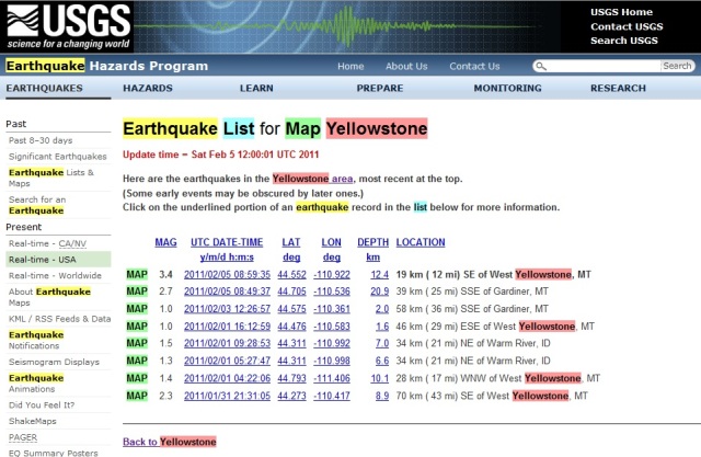
Earthquake List for Map Yellowstone
Update time = Sun Feb 6 10:00:03 UTC 2011
Here are the earthquakes in the Yellowstone area, most recent at the top.
(Some early events may be obscured by later ones.)
Click on the underlined portion of an earthquake record in the list below for more information.
MAG UTC DATE-TIME
y/m/d h:m:s LAT
deg LON
deg DEPTH
km LOCATION
MAP 1.7 2011/02/05 16:21:47 44.748 -111.114 5.1 10 km ( 6 mi) N of West Yellowstone, MT
MAP 1.0 2011/02/03 12:26:57 44.575 -110.361 2.0 58 km ( 36 mi) SSE of Gardiner, MT
MAP 1.0 2011/02/01 16:12:59 44.476 -110.583 1.6 46 km ( 29 mi) ESE of West Yellowstone, MT
MAP 1.5 2011/02/01 09:28:53 44.311 -110.992 7.0 34 km ( 21 mi) NE of Warm River, ID
MAP 1.3 2011/02/01 05:27:47 44.311 -110.998 6.6 34 km ( 21 mi) NE of Warm River, ID
MAP 1.4 2011/02/01 04:22:06 44.793 -111.406 10.1 28 km ( 17 mi) WNW of West Yellowstone, MT
MAP 2.3 2011/01/31 21:31:05 44.273 -110.417 8.9 70 km ( 43 mi) SE of West Yellowstone, MT
und das ist der Caches von gestern: